
climaemet provides access to meteorological observations, forecasts, alerts and climatology data from the Spanish Meteorological Agency (AEMET). It is part of rOpenSpain, a community that develops R packages for working with Spanish public data.
API key
Get an API key
To download data from AEMET, obtain a free API key from the AEMET OpenData registration page.
Once you have your API key, you can use any of the following methods:
Set the API key with aemet_api_key()
This is the recommended option. Run:
aemet_api_key("YOUR_API_KEY", install = TRUE)Using install = TRUE stores the API key on your local computer so it is available in future R sessions.
Use an environment variable
Alternatively, set the API key as an environment variable for the current session:
Sys.setenv(AEMET_API_KEY = "YOUR_API_KEY")You need to run this command again after restarting R.
Modify your .Renviron file
You can also store the API key permanently in .Renviron. Open the file with:
usethis::edit_r_environ()Then add the following line:
AEMET_API_KEY=YOUR_API_KEYData formats
Tabular results
climaemet returns tabular results as tibble objects. The package also infers column types when possible. For example, date and time columns are parsed as date-time objects and numeric columns are parsed as doubles.
The following call returns a tibble:
# Inspect a tibble.

aemet_last_obs("9434")
#> # A tibble: 13 × 25
#>    idema   lon fint                 prec   alt  vmax    vv    dv   lat  dmax
#>    <chr> <dbl> <dttm>              <dbl> <dbl> <dbl> <dbl> <dbl> <dbl> <dbl>
#>  1 9434  -1.00 2026-10-09 03:00:00     0   249  10.1   7.6   300  41.7   298
#>  2 9434  -1.00 2026-10-09 04:00:00     0   249  10.3   7     305  41.7   318
#>  3 9434  -1.00 2026-10-09 05:00:00     0   249   9.6   6.3   303  41.7   300
#>  4 9434  -1.00 2026-10-09 06:00:00     0   249  10.3   7.5   299  41.7   325
#>  5 9434  -1.00 2026-10-09 07:00:00     0   249  12.4   8.4   300  41.7   310
#>  6 9434  -1.00 2026-10-09 08:00:00     0   249  12.6   8.1   305  41.7   290
#>  7 9434  -1.00 2026-10-09 09:00:00     0   249  14.3   8.8   311  41.7   318
#>  8 9434  -1.00 2026-10-09 10:00:00     0   249  13.5   8.3   322  41.7   323
#>  9 9434  -1.00 2026-10-09 11:00:00     0   249  14.7   8     320  41.7   318
#> 10 9434  -1.00 2026-10-09 12:00:00     0   249  12.3   7.9   319  41.7   315
#> 11 9434  -1.00 2026-10-09 13:00:00     0   249  11.7   7.2   313  41.7   333
#> 12 9434  -1.00 2026-10-09 14:00:00     0   249  12.6   7.3   323  41.7   318
#> 13 9434  -1.00 2026-10-09 15:00:00     0   249  11.9   8     315  41.7   308
#> # ℹ 15 more variables: ubi <chr>, pres <dbl>, hr <dbl>, stdvv <dbl>, ts <dbl>,
#> #   pres_nmar <dbl>, tamin <dbl>, ta <dbl>, tamax <dbl>, tpr <dbl>,
#> #   stddv <dbl>, inso <dbl>, tss5cm <dbl>, pacutp <dbl>, tss20cm <dbl>
Spatial objects with sf
Data-access functions that support return_sf = TRUE can return spatial sf objects. These objects use the EPSG:4326 coordinate reference system (CRS), corresponding to the World Geodetic System 1984 (WGS 84), with unprojected longitude and latitude coordinates:
# You need to install sf if it is not already installed.
# Run install.packages("sf") to install it.

library(ggplot2)
library(dplyr)

all_stations <- aemet_daily_clim(
  start = "2021-01-08",
  end = "2021-01-08",
  return_sf = TRUE
)

ggplot(all_stations) +
  geom_sf(aes(colour = tmed), shape = 19, size = 2, alpha = 0.95) +
  labs(
    title = "Average temperature in Spain",
    subtitle = "8 Jan 2021",
    color = "Mean temp.\n(°C)",
    caption = "Source: AEMET"
  ) +
  scale_colour_gradientn(
    colours = hcl.colors(10, "RdBu", rev = TRUE),
    breaks = c(-10, -5, 0, 5, 10, 15, 20),
    guide = "legend"
  ) +
  theme_bw() +
  theme(
    panel.border = element_blank(),
    plot.title = element_text(face = "bold"),
    plot.subtitle = element_text(face = "italic")
  )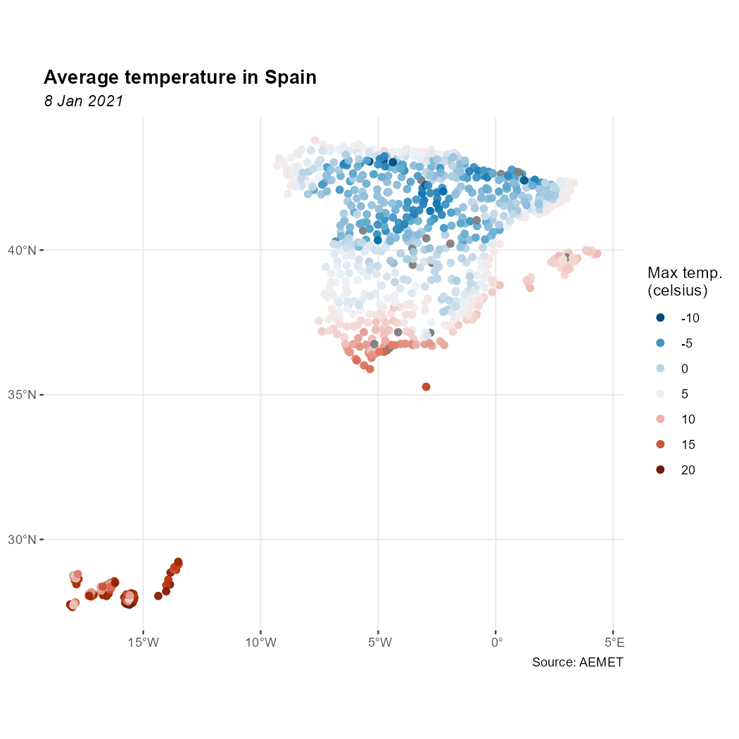
Example: temperature in Spain
Additional features
Other package features include:
- Data functions accept vector inputs where the AEMET OpenData API supports them.
-
get_metadata_aemet()retrieves metadata from arbitrary AEMET OpenData API endpoints. -
ggclimat_walter_lieth()creates Walter-Lieth climate diagrams and is the default plotting method used byclimatogram_normal()andclimatogram_period(). . Set
. Set ggplot2 = FALSEto useclimatol::diagwl()instead. - Plotting functions accept additional options through
.... - The example datasets
climaemet_9434_climatogram,climaemet_9434_tempandclimaemet_9434_windsupport the plotting examples.