CatastRo provides access to services from the Spanish Cadastre. With CatastRo, you can retrieve addresses, buildings, cadastral parcels and georeferenced map images, geocode cadastral references and reverse geocode coordinates.
Installation
Install CatastRo from CRAN:
install.packages("CatastRo")The SSL certificate of the Spanish Cadastre may cause errors when using CatastRo (especially on macOS, see issue #40).
In CatastRo >= 1.0.0, you can work around these errors by running this code after loading the package:
# Disable SSL verification
options(catastro_ssl_verify = 0)
To make this setting persistent, add the same code to your .Rprofile:
.Rprofile
# ... other options...
options(catastro_ssl_verify = 0)
Package API
The functions of CatastRo are organized by source service. The package naming convention is catr_*service*_*description*.
OVC services
OVC services use OVCCoordenadas for geocoding and reverse geocoding and OVCCallejero for province and municipality code lookup.
These functions use the catr_ovc_get_*() prefix and return tibbles from the tibble package. See vignette("ovcservice", package = "CatastRo") for a detailed description of these functions.
INSPIRE services
INSPIRE functions retrieve spatial objects from the Spanish Cadastre INSPIRE services using the sf or terra packages.
Note that these services cover 95% of the Spanish territory, excluding the Basque Country and Navarre1, which have their own independent cadastral offices.
There are three INSPIRE services:
ATOM service
The ATOM service downloads complete municipal datasets for different cadastral elements. Results are returned as sf objects from the sf package.
These functions use the catr_atom_get_*() prefix.
WFS service
The WFS service downloads vector objects for specific cadastral elements. Results are returned as sf objects from the sf package. Note that there are restrictions on the extent and number of elements that can be queried. For full municipal downloads, prefer the ATOM service.
These functions use the catr_wfs_get_*() prefix.
WMS service
The WMS service downloads georeferenced map images for different cadastral elements. Results are returned as SpatRaster objects from the terra package.
There is a single function for querying this service: catr_wms_get_layer().
Terms and conditions of use
Please check the service terms of use.
Examples
These examples highlight some features of CatastRo:
Geocode a cadastral reference
library(CatastRo)

catr_ovc_get_cpmrc(rc = "13077A01800039")
#> # A tibble: 1 × 10
#>   xcoord ycoord refcat     address pc.pc1 pc.pc2 geo.xcen geo.ycen geo.srs ldt
#>    <dbl>  <dbl> <chr>      <chr>   <chr>  <chr>  <chr>    <chr>    <chr>   <chr>
#> 1  -3.46   38.6 13077A018… DS DIS… 13077… 18000… -3.4575… 38.6184… EPSG:4… DS D…
Reverse geocode coordinates to a cadastral reference
catr_ovc_get_rccoor(
  lat = 38.6196566583596,
  lon = -3.45624183836806,
  srs = "4230"
)
#> # A tibble: 1 × 8
#>   refcat         address           pc.pc1 pc.pc2 geo.xcen geo.ycen geo.srs ldt
#>   <chr>          <chr>             <chr>  <chr>     <dbl>    <dbl> <chr>   <chr>
#> 1 13077A01800039 DS DISEMINADO  P… 13077… 18000…    -3.46     38.6 EPSG:4… DS D…
Extract geometries using the ATOM service
bu <- catr_atom_get_buildings("Nava de la Asuncion", to = "Segovia")

# Map.
library(ggplot2)

ggplot(bu) +
  geom_sf(aes(fill = currentUse), col = NA) +
  coord_sf(
    xlim = c(374500, 375500),
    ylim = c(4556500, 4557500)
  ) +
  scale_fill_manual(values = hcl.colors(6, "Dark 3")) +
  theme_minimal() +
  labs(title = "Nava de la Asunción, Segovia")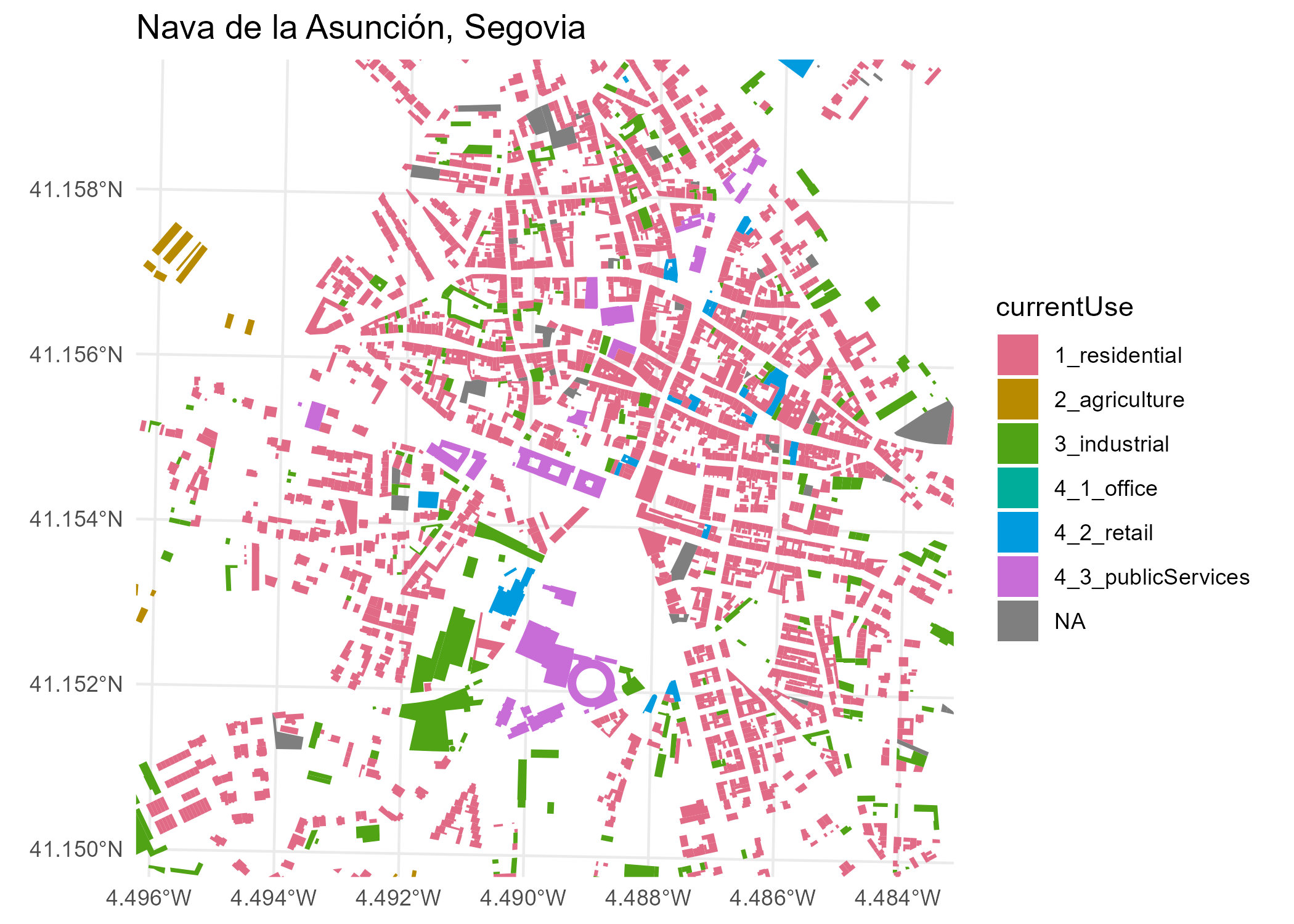
Extract geometries using the WFS service
wfs_get_buildings <- catr_wfs_get_buildings_bbox(
  c(-4.134, 40.952, -4.131, 40.953),
  srs = 4326
)

# Map.
ggplot(wfs_get_buildings) +
  geom_sf() +
  labs(title = "Alcázar of Segovia, Segovia, Spain")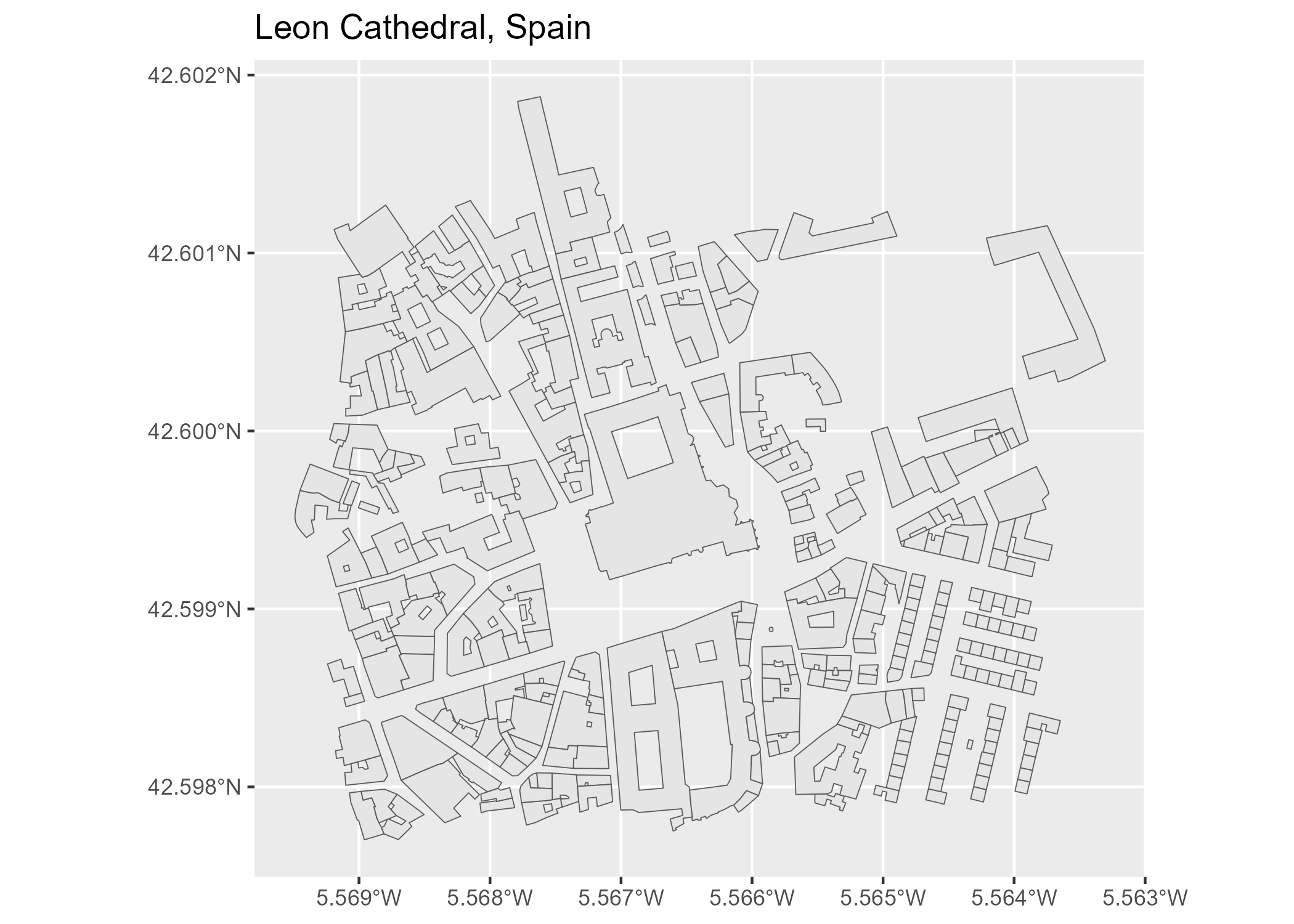
Cache management
Some datasets and tiles may exceed 50 MB. You can set a local cache directory using the following function:
catr_set_cache_dir("./path/to/location")When a cache directory is configured, CatastRo reuses downloaded files, which speeds up repeated queries.
Citation
Delgado Panadero Á, Hernangómez D (2026). CatastRo: Interface to the API Sede Electrónica Del Catastro. doi:10.32614/CRAN.package.CatastRo. https://ropenspain.github.io/CatastRo/.
A BibTeX entry for LaTeX users is:
@Manual{R-CatastRo,
  title = {{CatastRo}: Interface to the {API} Sede Electrónica Del Catastro},
  author = {Ángel {Delgado Panadero} and Diego Hernangómez},
  doi = {10.32614/CRAN.package.CatastRo},
  year = {2026},
  version = {1.0.2},
  url = {https://ropenspain.github.io/CatastRo/},
  abstract = {Access public spatial data from the Spanish Cadastre through its INSPIRE and related web services. Retrieve cadastral parcel, building, address and georeferenced map image data and convert between cadastral references and coordinates.},
}
Contributing
See the source code and issue tracker on GitHub.